Part 1 detailing our travel days and intro can be found here.
Part 2 detailing our first night and full day in Istanbul can be found here.
We wised up on our second day. Well, a little. After 8-9 miles just getting to places on day 1, we realized that we'd need to take some public transport if we wanted to make it through the rest of the trip. Especially since day 2 would include two purposeful walks. Since day 1 was the touristy highlights of the city, I wanted to have a bit of a different tone on day 2. The book suggested a few walks, including wandering around the Asian side and exploring the Theodosian walls. Our sunset cruise was moved from day 1 to day 2 because of the rain, so we had an early start with our "free" breakfast and we headed out to the nearest metro station (see, we were learning) to catch a ferry across the Bosphorus. Istanbul has "Istanbulkart," a reloadable hard plastic card that can be used on all types of public transportation. It is extremely convenient and can be used by multiple people. At least, the police sitting at the stations didn't stop us when I'd pass the card to Mila. Each ride costs roughly 50 cents and the system seems to be clean and well maintained, so it's a good way to get around. Much cheaper than taxis and with less traffic-stopping fights.
Again, it was rainy, dreary, and chilly.
 |
| Fishermen braving the weather |
 |
| A monument showing the year of Mehmed's conquest |
 |
| 1923, the year the Ottoman Empire fell and Turkey became a secular republic |
 |
| chilly Mila in front of a monument celebrating the heroes of 1923 |
We got off the ferry in Uskudar, a middle class neighborhood in Asia. We used the bathrooms at the large Mihrimah Sultan mosque (gotta use them free ones), and ambled around the shops and cafes. There were no tourists or tourist traps here. OK, maybe with the exception of Hollywood Ice Cream. We started counting the stray cats as there were dozens if not hundreds that we saw in our 5 days in Istanbul. After a loop inland, we headed to the walk along the strait. We didn't exactly follow Rick Steve's walk but chose our own adventure.


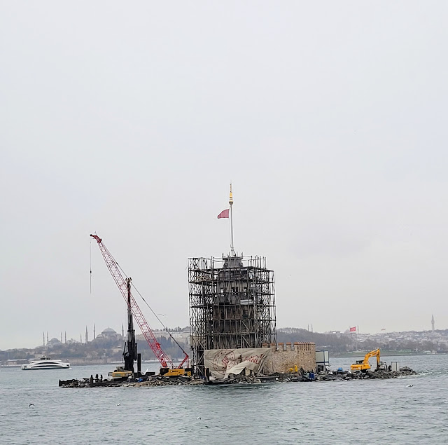
The turnaround point of our walk was the Maiden's Tower. As you can see, it's under renovations. There are some interesting legends about this tower. It sits on a small island just off the coast and has had several iterations of watchtowers, quarantine location, and customs stations for roughly 2500 years. A chain that went across the strait in Byzantine times had an anchor point here. The current tower was built in 1763. The name purportedly comes from a legend about the emperor's favorite daughter. An oracle prophesied that she would be killed on her 18th birthday by snake bite. So, to keep her safe, he built the tower and locked her up there. As one does. He had the rock cleared of snakes and was the only person allowed to visit her. He would bring her food, water, and books to read. On her 18th birthday he visited with a basket of fruit to celebrate. A venomous snake hid in the basket and bit her, killing her. The other story is a misplaced Greek myth. In any event, there's no real answer to how it got its name if not simply basing it upon the legend.


We gazed off into the Sea of Marmara for a few moments before heading back the way we came to get 2nd breakfast. This was when we really realized we'd stepped off the tourist beaten path. None of the waiters spoke English or Spanish. Luckily, the menu had pictures. This is also where we learned how to say apple tea in Turkish - elma çayı (el-muh chai). I had the best omelet I'd ever had, and we enjoyed a nice rest while staring out over the water
 |
| while not as widespread as the apple tea, sahlep is a Middle Eastern specialty that I came to really like. I'd seen it advertised at a bunch of places and the pictures made it look tasty so I tried it without knowing what it was. Imagine horchata served hot but thicker. The real stuff has ground orchid tubers as its base. Since its popularity is putting some strains of orchid in danger of extinction, much of it, and all exported varieties, is now powder-based. Not sure which this is. |
We walked around and snapped a few more pictures before hopping on a ferry to start walk #2.
Walk #2 was Rick Steve's "Theodosian Walls" walk. Again, we were going to just meander as it was pointless to try and set waypoints on our GPS. We decided to start at Chora Church and see what we see from there. However, we realized that we were already walking along the walls on the way.
We walked through middle and lower class neighborhoods past apartment complexes, condos, school, and little markets. An old lady was hanging her underwear out to dry on the Theodosian walls. We saw probably 38 cats and this was another area where the locals gave us weird looks.

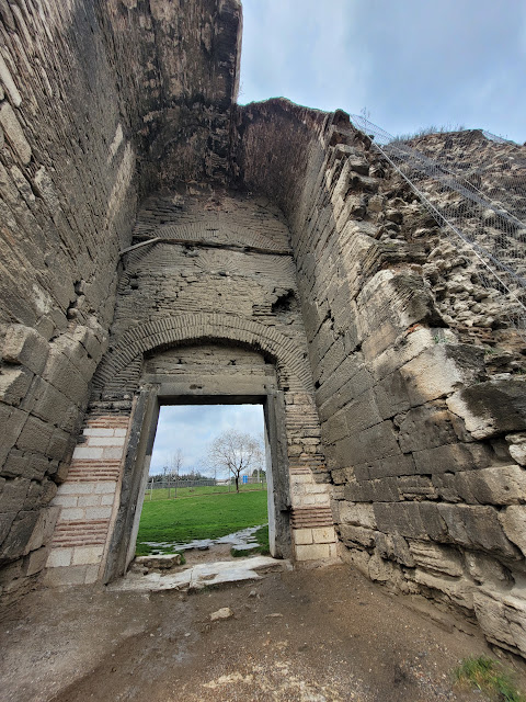
The Theodosian walls were a continuation and upgrade of the older walls of the city. As with most cities in antiquity, there have almost always been walls. Constantine greatly improved and expanded the existing walls when he re-founded the city. However, Theodosius had the impressive doubled-walled system put in place that stood for some 1000 years. It wasn't until Mehmed's basilic cannon that could shoot a 1500 pound projectile that they really were knocked down. Even then, it took days and an overwhelming advantage in numbers to truly defeat the Byzantines hiding behind their walls. Arabs, Vikings, and Rus all tried their hand at toppling them over the centuries without success. Sections still stand today but they are very much within city limits instead of being the border of the city.

Our first official waypoint was what used to be Chora church and what will now be Kariye mosque. It is nearly 900 years old and boasts beautiful murals from the 14th century. At least, that's how they look in the pictures that I saw. It is closed down while they make the switch to a mosque. It too has bounced between church, mosque, and museum in its history and I can only hope that they preserve the history like they did in Hagia Sophia.
We wandered through the streets, keeping close to the walls while trying to decide where to go next for lunch and a bathroom break. We definitely were far away from the tourist areas and there didn't even seem to be any restaurants nearby either.
 |
| the courtyard and one of the 4-5 cats we saw hanging out there |
We came across Tefkur Palace, also known as Palace of the Porphyrogenitus, the best-preserved Byzantine palace still standing today. After the Conquest, it was used as a menagerie and brothel before becoming a pottery factory in the 18th century. The majority of the exhibitions now detail the pottery made at the palace in the past few centuries. One beautiful example of tiles from the palace was found in a neighborhood mosque nearby. We took the walk over there but there were explicit "no pictures" signs up.
 |
| oh yeah, the rain stopped sometime while we were walking along the walls too |
 |
| the palace was part of the Theodosian walls. If I remember correctly, this is a view looking out from the walls to what was outside of the city. |
We were pretty far away from the nearest metro so we started walking towards the Golden Horn and ended up coming across some cafes and a university. We stopped in one of the restaurants where I had my first taste of "observation." It like a quesadilla made with flaky bread, super tasty. No idea why it's called observation but I'm a fan.
 |
| The little side street by our café displaying all the flags |
From there we went to one of the many ports along the Bosphorus to catch our yacht cruise. We got aboard the 35ish foot luxury yacht with roughly a dozen other people, not counting the crew. We sailed north, covering most of the strait (it's only about 17 miles long in total), following the European side and then back down the Asian. We had some snacks and a guide that spoke decent English and Spanish. I'll do my best to remember what we were taking pictures of or at least try and look it up online.
 |
| some of the boats around the port of Kabatas |
 |
| the view of Dolmabahce palace, the last palace of the Ottoman Empire. Built in the mid-19th century so that the sultan could have a more contemporary, luxurious, European palace, it ended up putting the country into further debt and cost roughly 25% of the government's annual tax revenue. I wanted to check it out but it required tickets to be bought in advance and we didn't squeeze it in. |
 |
| Ortakoy Mosque |
 |
| a look of the back of the yacht with the Bosphorus/15 July martyrs bridge. It was the first bridge built across the strait, finishing construction in 1973. |
 |
| It stopped raining but it was still chilly, in the low 40s |
 |
| Galatasary island which was given to the sports club. Apparently there was a fire sometime in the past year |
 |
| The Rumelihisari fortress was built by Sultan Mehmed in 1451 in preparation for the siege of Constantinople. He used it to control naval traffic and support in and out of the city |
 |
| The Bosphorus is still a viable international shipping lane |
 |
| Kucuksu Pavillion, where the sultan would stay during hunting trips. This structure was built in the mid-19th century but there had been a "hunting cabin" for the sultans there since the 17th century |
 |
| of course they gave us some tea (black, not apple this time) and of course Mila had to get a picture of it with the flag |
 |
| from the other side of the Maiden's Tower |
 |
| after 2 rainy days, we were lucky to have such a pretty sunset |
 |
| North side of the European side. You can see Galata Tower straight ahead. Suleymaniye Mosque is on the left, Galata Bridge on the right. I'm not exactly sure which mosque is on the right |
 |
| 15th of July Martyrs Bridge |
 |
| Dolmabahce and 15 July |
After the cruise, we jumped on the train back to the hotel. The closest tram station dropped us off by Sultanahmet square, so we ended up with some more views of the Blue Mosque

The next morning, it was on to Cappadocia! We went to the smaller airport, Sabiha Gokcen. It is small, so we had no problems getting through. And the rest, dear reader, will come in the next entry!


Comments
Post a Comment